This is the most complete guide you'll find on the Caminito del Rey. If you read everything here, you'll arrive better prepared than 95% of visitors.
What the Caminito del Rey is
The Caminito del Rey is a 7.7 km trail that runs through the interior of the Gaitanes gorge, in the province of Málaga. It was built in 1905 by workers from the Chorro Hydroelectric Plant to connect the system's two dams. It was closed and deteriorating for decades until it was rehabilitated and reopened to the public in 2015.
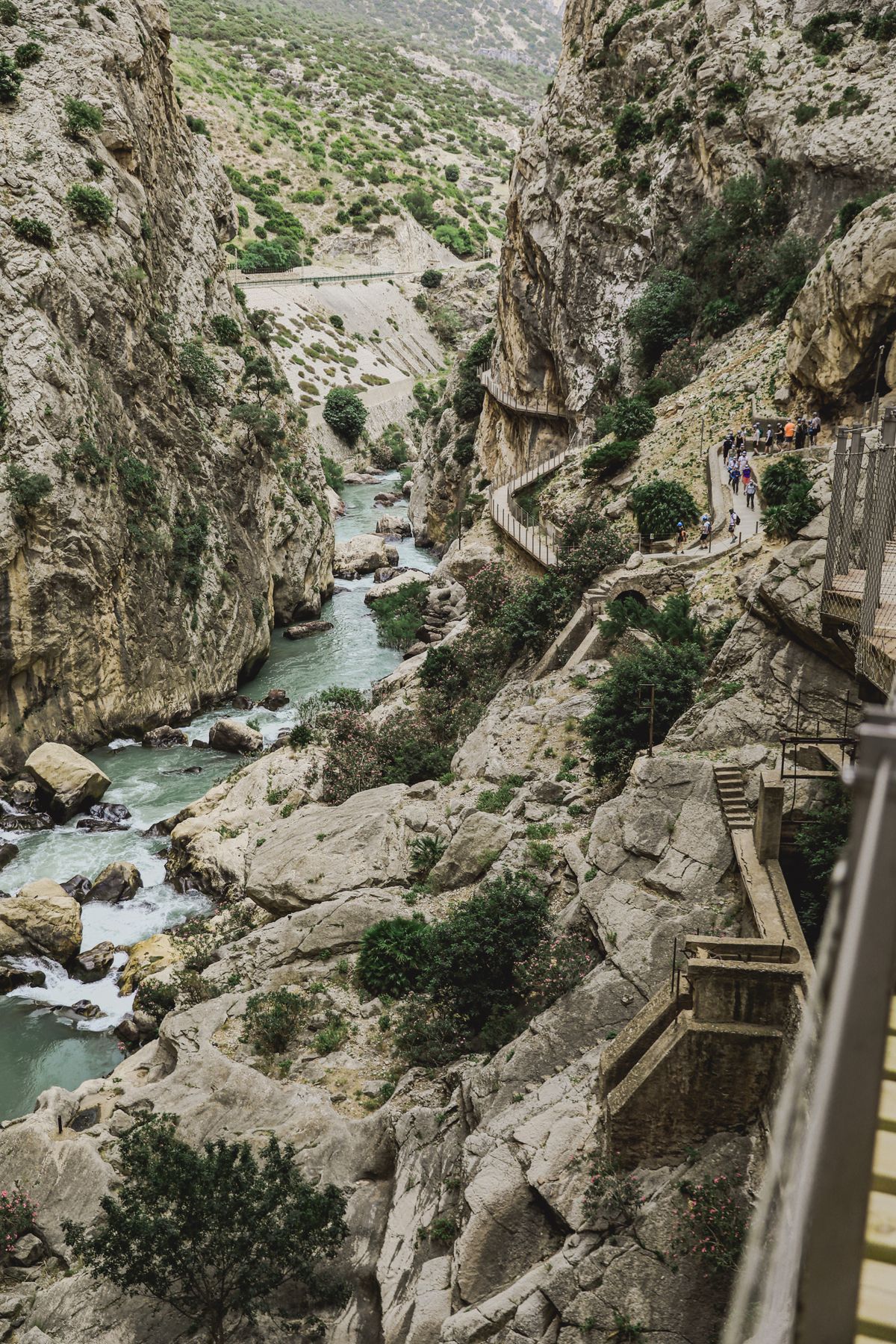
What makes it unique: the wooden walkways fixed directly to the vertical wall of the canyon, more than 100 meters above the river. It's not a conventional hiking trail — it's a combination of industrial history, engineering, and natural scenery with no equivalent in Spain.
Tickets
Where do you buy them? Official tickets are only sold online on the park's website. They are not sold at the box office on the same day.
How much do they cost? Approximately €10 per person at the standard rate (check the current price on the official website).
How far in advance do you need to book? It depends on the season:
- Easter and spring long weekends: 2-3 months ahead
- April-June weekends: 4-6 weeks ahead
- Spring/summer weekdays: 2-3 weeks
- Autumn and winter: 1-2 weeks is usually enough
What if the website is sold out? Organized tours have their own allocation. When the official website has no tickets left, tours may still have availability.
How to get there
By car: the most practical way. From Málaga it's about 55 km (1h) via the A-357 toward Ardales.
On a tour from Málaga: the most convenient option if you don't have a car. Includes transport, a guide, and in the full version, the entry ticket.
By train: Cercanías C-2 commuter line from Málaga to El Chorro station (1h, price ~€4-5). Useful if you have schedule flexibility.
Parking and the shuttle
The route is linear — you enter at one end and exit at the other. The recommended system:
- Park at the south car park (next to the Ardales Visitor Center)
- Take the shuttle to the north access (~€1.55 per person)
- Do the route from north to south
- Finish next to your car at the south access
Arrive at the south car park 30-40 minutes before your entry slot to have some margin.
What to bring
Mandatory:
- Closed footwear (if you show up in sandals, you won't get in)
- ID or passport (tickets are name-specific)
Highly recommended:
- Water: minimum 1 liter per person (1.5L in summer)
- Snacks for a 4-hour route
- Sunscreen and sunglasses (summer)
- Layered clothing (winter)
Prohibited:
- Trekking poles
- Umbrellas
- Selfie sticks
- Pets
- Baby strollers
The helmet is given to you at the control booth, free of charge and mandatory.
The route
Distance: 7.7 km one-way Elevation gain: minimal (100m accumulated, essentially flat) Duration: 3-4 hours (groups with children or older adults: 4-5h) Direction: north-south only, no option to do it in reverse
The 5 stretches:
- North access (km 0-2): quiet forest path to get acclimated
- Entrance to the gorge (km 2-3.5): the walls close in, first walkways
- Gaitanejo walkways (km 3.5-5.5): the spectacular stretch, 100m above the river
- Hanging bridge (km 5.5): the highlight, with views in every direction
- Exit to the south access (km 5.5-7.7): the canyon opens up, back to the forest
When to go
| Season | Temperature | Tickets | Notes |
|---|---|---|---|
| January-February | Cold | Easy | Risk of closure due to rain |
| March | Ideal | Easy | A great underused option |
| April-May | Ideal | Hard | The best season, book 6-8 weeks ahead |
| June (1st half) | Good | Normal | Go in the first slot |
| July-August | Hot | Normal | Avoid if possible; go very early and very hydrated |
| September-October | Good | Normal | The second-best season |
| November-December | Cool | Easy | Risk of closure due to rain |
The height factor
There are stretches over 100m above the river, with railings. People without a fear of heights have no problem. People with acrophobia can freeze up — it's a real risk worth assessing before going.
There's no exit halfway through the route if someone freezes up or gets tired. You have to finish.
What you'll find in the area
- The Chorro reservoir: next to the north access, a spectacular green-turquoise color
- Ardales: a town 4km from the south access, set menus with regional cuisine
- Ardales Caves: Paleolithic cave paintings
- Climbing in El Chorro: a benchmark area in southern Spain
- Campillos Lagoons: flamingos and waterfowl (30km away)
Quick questions
Are there bathrooms on the route? No. Only at the start and the end. Is there drinking water? No. Bring your own. Is there phone signal? Variable, not reliable inside the canyon. Can you go with a dog? No. What's the total cost? With your own car: ~€15-20 (ticket + shuttle + gas). With a full tour: €45-55.
This guide is updated regularly. If you have specific questions not covered here, the blog articles go deeper into each topic: how to get there from Málaga, Granada, and Seville, what to bring, the history of the Caminito, where to stay, and much more.
✓ Guaranteed Availability 2026
Ready to visit Caminito del Rey?
Official tickets sell out months in advance. Book your guided tour with free cancellation up to 24 h before.
See availability and price →⚡ Free cancellation · Instant confirmation