The Caminito del Rey isn't a conventional mountain trail. It has stretches of dull forest track, but it also has sections that will leave you literally speechless. Knowing what to expect in each part helps you pace yourself properly — don't rush the first kilometers just to arrive fresh at the part that's actually worth it.
The full route is 7.7 km, always walked north to south (from the El Chorro access to the Ardales access), and it splits into two main blocks: the forest access trail and the spectacular walk through the gorge.
Route technical data
- Total distance: 7.7 km
- Elevation gain: 105 m ascent / 130 m descent (essentially flat)
- Average duration: 3 to 4 hours (with stops)
- Difficulty: Low-medium (the distance is manageable, the challenge is psychological in the exposed stretches)
- Mandatory direction: North to South
Section 1: North access — El Chorro (km 0 to km 2)
The beginning is calmer than most people expect. From the control booth at the north access, the path runs along a forest track through pines and Mediterranean vegetation. No walkways, no exposure, nothing especially dramatic.
This stretch exists out of necessity: it connects the parking lot and control booth to the start of the gorge. Use it to get into your pace, adjust your helmet, drink water, and mentally prepare for what's coming.
What you will find here:
- The first views of the Chorro reservoir to your left, with that green-turquoise color that defines these waters
- A gentle descent toward the Guadalhorce River
- Clear signage with route maps
Pacing tip: don't rush here. It's tempting because the terrain is easy, but you'll want energy for the central section.
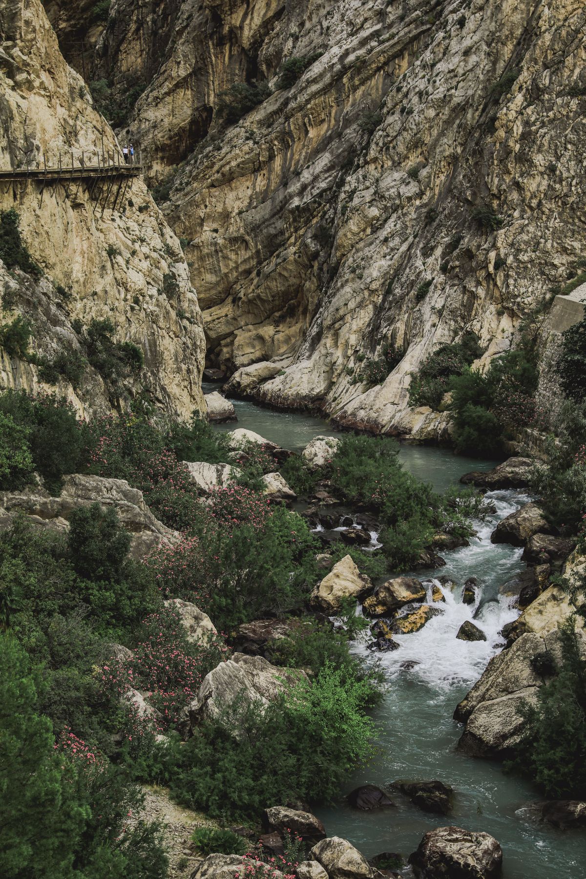
Section 2: Entering the gorge (km 2 to km 3.5)
This is where everything starts to change. The path narrows and the rock walls of the Gaitanes gorge begin closing in on both sides. The vegetation disappears and the landscape turns mineral, with vertical limestone walls rising hundreds of meters.
In this section you'll see, for the first time, the remains of the original 1905 path — the trail built by the workers of the hydroelectric plant to connect the system's two dams. A narrow strip of aged concrete clinging to the rock, with no railing, deteriorated. That's the original Caminito del Rey, the one that stayed closed for decades.
The new wood-and-steel walkways run parallel to the original path, with railings and perfectly safe. But seeing the old path right there alongside gives you a very concrete sense of what this place was like before the restoration.
The point of no return: this section is where most people with a fear of heights feel the first symptoms. The walkways have safety netting, but the void below is real. If you're doing fine here, you'll be fine for the rest of the route.
Section 3: The Gaitanejo walkways — the star stretch (km 3.5 to km 5.5)
This is the heart of the route and the reason people come from all over the world. The wooden walkways literally cling to the vertical canyon wall, with the Guadalhorce River roaring hundreds of meters below.
There are stretches where the walkway is just one meter wide, rock on one side and open air on the other. The views are absolutely vertical: look down and you see the river, look up and you see the sky framed between two stone walls.
The most photogenic points on the entire route:
- The first high-exposure turn: where the walkway bends and you see the canyon's true depth for the first time. Many people stop here for several minutes.
- The stretch over the void: the most exposed section, where the walkway projects out from the wall with no rock on either side, only railing.
- The view of the suspension bridge: before reaching it, there's a bend from which you can see the bridge suspended in midair with the canyon behind it. It's the most reproduced image of the Caminito.
This section is also where the Málaga-Córdoba railway line trains pass, cutting through the gorge via tunnels carved into the rock. Watching them go by from the walkways, at the same height or even below you, is a surreal sight.
Section 4: The suspension bridge (km 5.5)
The suspension bridge is the high point of the route for many people. It crosses the gorge from side to side, suspended in midair, with the river far below. It has solid railings and a wooden plank floor.
What makes this bridge special isn't its length (about 30 meters) but its position: you're at the center of the gorge, rock walls on both sides, the river below, the sky above, and nothing else. It's the only point on the route where you're completely surrounded by open air in every direction.
For those with a phone in hand: this is the spot for photos. From the center of the bridge looking north (back toward the walkway stretch you just walked), the view is spectacular. Morning light comes in from that side if you go in the first slot of the day.
Some visitors feel more vertigo on the bridge than on the walkways, because the subtle movement of the bridge as other people walk across adds a sense of instability. It's normal and it's safe.
Section 5: Leaving the gorge and the south access (km 5.5 to km 7.7)
After the bridge, the gorge gradually opens up. The rock walls pull apart, light returns, and the path widens again into a forest trail similar to the north access.
This exit stretch is longer than it seems after the intensity of the gorge. The adrenaline from the central section fades, and the last two kilometers can feel heavier than expected, especially in the heat.
What you'll find at the end:
- South access visitor center, next to the Ardales road
- Food and drink stalls: sandwiches, hot dogs, cold drinks. After 4 hours of walking, this tastes like heaven
- Shuttle stop to get back to the north parking lot if you left your car there
- Rest area with tables and benches
What the official map won't tell you
The park map shows the route but doesn't tell you that:
- The first 2 km are the least interesting and the last 2 km are the lowest-intensity. 70% of what's worth seeing is between kilometers 3 and 5.5.
- The gorge causes the temperature to vary by stretch: cool, sometimes with a breeze, inside the canyon; hot and sunny in the open stretches.
- You'll hear the water long before you see it. Once you start hearing the river clearly, you're about to enter the good part.
- Wildlife is more active than you'd expect. Griffon vultures regularly soar over the gorge, and swifts and other birds of prey nest in the rock walls.
The route is linear and there are no shortcuts. If you've read this far through the full description, you already have more information than 90% of visitors. The next step is securing your ticket.
✓ Guaranteed Availability 2026
Ready to visit Caminito del Rey?
Official tickets sell out months in advance. Book your guided tour with free cancellation up to 24 h before.
See availability and price →⚡ Free cancellation · Instant confirmation